Area mapping for water and forest based on satellite hyper-spectral remote sensing
-
摘要:
高光谱卫星的出现和发展为遥感测绘提供了新的技术手段。与传统卫星图像相比,高光谱卫星图像含有更为丰富的光谱信息,能够对目标物进行更为准确的鉴别、分类、定位和测绘。以“珠海1号”高光谱卫星(OHS-C)所提供的高光谱卫星图片为样本,利用地物反射光谱结合自适应算法实现了对林木和水体的精确鉴别、增强标记和面积测量。利用比值法对光谱进行处理,在无需复杂校准的情况下便可去除大气情况及时间季节对光谱的影响。实验结果表明林木和水体鉴别的特异性和灵敏度均高于97%。依据本文设计的鉴别模型,计算得西丽水库官方水域计算总面积数约为4.6 km2,与官方数据的误差仅约为0.1446 km2;计算得淇澳岛的绿化面积为22.1713 km2,该岛总占地面积为23.8 km2,按照90%绿化面积计算得误差小于0.7513 km2,且误差主要源于商用卫星的空间分辨率不足。
Abstract:The emergence and development of hyper-spectral satellites provide a new technical means for remote sensing and mapping. Compared with the traditional satellite images, the hyper-spectral satellite images contain the richer spectral information, which can carry out more accurate identification, classification, positioning and mapping of target objects. Taking the hyper-spectral satellite images provided by the Zhuhai No. 1 hyper-spectral satellite (OHS-C) as the sample, the accurate identification, enhanced marking and area measurement of forest and water were realized by combing ground clutter reflection spectrum with adaptive algorithm. The ratio method was used to process the spectrum, and the influence of atmospheric conditions and time as well as season on the spectrum can be removed without the complex calibration. The experimental results show that the specificity and sensitivity of identification of forest and water is higher than 97%, respectively. Based on the proposed identification model, the calculated total area of the official waters of Xili Reservoir is about 4.6 km2, and the error with the official data is only about 0.144 6 km2. The green area of Qi'ao Island is calculated to be 22.171 3 km2, and the total area of the island is 23.8 km2. According to the calculation of 90% of the green area, the error is less than 0.751 3 km2, and the error mainly comes from the insufficient spatial resolution of commercial satellites.
-
Keywords:
- hyper-spectral satellites /
- area mapping /
- spectral imaging /
- BP neural network
-
引言
联合国粮农组织发布的《2015年全球森林资源评估报告》[1]中指出全球平均碳储量值为每公顷74吨,在过去的25年中全球森林生物质的碳储量减少了近111亿吨,主要是林地转化为居住用地和农业用地以及林地退化所导致。而我国陆生野生动植物物种的80%以上生存于森林[2],保护和监测森林资源显得尤为重要。与此同时,根据国家水利部、生态环境部、农业农村部联合印发的《重点流域水生生物多样性保护方案》[3],由于栖息地丧失和破碎化、资源过度利用、水环境污染、外来物种入侵等原因,导致了部分流域水生态环境不断恶化、珍稀水生野生动植物濒危程度加剧的情况,迫切需要更完善的措施以维护水生生物的多样性。由于人类行为、自然环境变化都会引起森林或者水体的面积变化,并继而引发一系列的生态变化,因此,采用高精度的科学手段对森林水体面积进行持续观测或测绘对生态保护工作意义重大。
航拍和卫星遥感是目前常用的持续监测水体和森林面积变化的方法,但是传统的遥感成像仅能采集地上目标物的形貌信息以及极少的光谱信息,无法对复杂的地貌进行精准鉴别和自动测绘。高光谱卫星的出现,在很大程度上提高了目标物精准识别和定量分析的能力。高光谱成像技术是通过拍摄目标物一系列窄波段的影像构成光谱立方体,进而获得目标物的二维空间信息和光谱信息[4]。目前,全球商用的高光谱卫星数量不多,但已经广泛应用于各种地貌的鉴别和面积测绘上。如张东东等人进行了中国南方地区甘蔗面积提取研究[5],何坦等人进行了鄱阳湖水体面积快速监测[6],Wegayehu Asfaw等人研究了埃塞俄比亚裂谷盆地湖泊的储存变化[7],Asner等人完成了近实时毁林的监控[8],Chasmer L.等人进行了湿地生态系统状态评估[9],Yagmur等人对科尼亚封闭盆地进行了流域管理[10],Gbagir等人对纳米比亚的植被进行监测[11]。本文通过高光谱卫星所采集的图片,研究对森林和水体进行鉴别和面积测绘的方法。
由于大气变化、日照情况变化均会造成卫星所采集的高光谱图像的变化,其反演所得地物的表面反射率会存在误差,在鉴别和测绘时,该误差将对结果产生严重影响。为了进一步提高鉴别精度,通常需要进行大气校准,如彭继达等人在平潭综合实验区设置区域前后植被变化特征分析中采用FLASSH大气校正法以及MODTRAN4+辐射传输模型去除大气中水汽、气溶胶散射效应[12],张春桂等人在厦门市植被覆盖遥感监测时则采用辐射传输6S模型法进行大气校正[13],Gregory W.等人对美国德尔马瓦半岛森林湿地淹没面积进行了测绘,利用快速视距大气分析进行大气校正[14]。虽然对光谱的大气校正方法非常多,但这些方法通常需要利用到地表光谱测量、校准光校正等辅助手段,或者采用以前采集的标准数据对光谱进行修正。这些技术虽然可以有效地校准大气对光谱的影响,但是技术较复杂且需要以往的数据支撑,在缺乏以往数据时往往无法对目标物进行鉴别。考虑到在森林和水体的鉴别中主要是实现两者之间以及与其他目标物之间的区分,而不是研究其光的吸收特性,本研究着重利用比值,依据水体这个容易在图中被辨认出来的目标物的光谱作为参考光谱,且对其他物体的光谱进行预处理,使得目标物之间的光谱差异不受大气和日照变化等因素的影响。
本研究采用“珠海1号”高光谱卫星(OHS-C)数据,结合光谱预处理和BP(back propagation)神经网络自适应算法,对广州市南沙地区的水体和森林进行了鉴别和面积测绘,结果显示,鉴别的灵敏度和特异性高于97%以上。更进一步的,我们根据鉴别结果对图内的水体和林木面积进行了测绘,并选取了西丽水库对测绘结果进行评价。西丽水库官方水域面积数据约为4.6 km2,测绘的面积与地面丈量面积的约相差0.1446 km2,误差为3.14%,其误差主要受卫星分辨率较低以及鉴别准确率未能达到100%的影响。
1 数据采集和数据分析
1.1 “珠海一号”卫星简介
“珠海一号”是目前国内完成发射并成功组网的商业遥感卫星星座。整个星座由34颗卫星组成,包括视频卫星、高光谱卫星、雷达卫星、高分光学卫星和红外卫星。本次研究数据来源于是2018年4月26日发射升空的星号为OHS-C的高光谱卫星。我们选取了地物较为丰富的广州市南沙区滨海地域作为研究对象。该地区包含了南沙区城区及深圳部分城区、森林公园、水库、水田、湖泊、南海部分海域、岛屿等不同地物。本研究采用的光谱图像均已进行相对辐射定标及几何校正。OHS-C高光谱卫星的详细参数如表1和表2所示。
表 1 “OHS-C”高光谱卫星拍摄数据简介Table 1. Brief introduction of “OHS-C” hyper-spectral satellite shooting data内容 简介 星号 OHS-C 左上角点经纬 Lon. E113°36′48′′ Lat. N22°45′11′′ 成像时间 2018年9月15日 侧摆角 −10.326° 太阳高度角 62.073° 影像分辨率 5056× 5056 像素 轨道高度 520 km 地物描述 城市、森林、湖泊、海洋 地面分辨率 10 m 数据处理等级 1级 已完成预处理项 相对辐射定标、几何校正 表 2 “OHS-C”高光谱卫星中心波长表Table 2. Central wavelengths of “OHS-C” hyper-spectral satellite通道数 中心波长/nm 通道数 中心波长/nm 1 466 17 716 2 480 18 730 3 500 19 746 4 520 20 760 5 536 21 776 6 550 22 790 7 566 23 806 8 580 24 820 9 596 25 836 10 610 26 850 11 626 27 866 12 640 28 880 13 656 29 896 14 670 30 910 15 686 31 926 16 700 32 940 1.2 地物的光谱特点
高光谱卫星采集的是地物对太阳光的反射光谱图像,根据本次采用的卫星图像的地貌情况,我们将地物简单地分为林木、水体和建筑物3类。
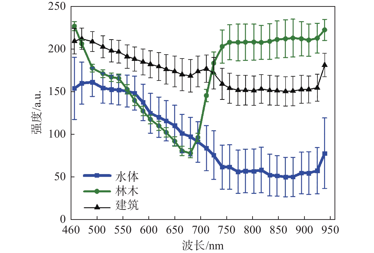
1) 对于林木而言,植物叶绿素a和叶绿素b在550 nm绿光处有一个反射峰;在660 nm红光波段附近出现反射率较低的吸收谷;在700 nm~780 nm波段出现植被反射率红边,其形成原因是该波段为介于叶绿素对红光波段强吸收和对近红外波段高反射的过渡阶段;而在780 nm~1350 nm波段由于植被反射率高且稳定,形成了反射率平台。卫星的第13通道、第16至21通道的波段以及第31至32通道的波段能够反映叶绿素上述光谱特征。
2) 水体的光谱特征曲线不但由水本身的性质决定,也会受到不同水状态的影响,例如浮游生物带来的叶绿素、悬浮泥沙、营养盐含量、其他污染物、水域底部形态和水深等。对于清水,在可见光波段600 nm之前,水对光的吸收少、反射率较低;而在750 nm以上的近红外、中红外部分水体则几乎全部吸收其入射能量。含有叶绿素的水体中,水体的光吸收特性会受叶绿素对光的吸收特性影响而产生变化。在有悬浮泥沙的水体中,随着水的浑浊度增加,水体在可见光谱段的反射亮度增加,同时反射峰值波长出现红移,反射峰值波长向长波方向移动,使反射峰本身的形态变得更宽。水深对光谱特征的影响主要由水对能量的吸收导致,蓝绿波段穿深能力强,红光区穿深能力弱,随着水深的增加,光谱曲线向左下方偏移。卫星的光谱通道可捕捉上述特征。
3) 建筑物的光谱特征与道路接近,光谱曲线比较平缓,与其他目标地物相比,其整体反射率较高,对各个波长散射类似,且影像灰度的标准差不明显。不同的建筑屋顶类型其反射率也不同,石棉瓦屋顶(灰白色)反射率最高,沥青粘沙屋顶比灰色水泥屋顶反射率高。城市中的道路主要由水泥和沥青两大类作为铺面材料,在部分区域内会有少量土路。这3种路的反射波谱曲线大体相似,在400 nm~600 nm缓慢上升,后趋于平缓,并在900 nm~1100 nm逐渐下降。水泥路呈灰白色,反射率最高,其次为土路,沥青路反射率较低。由于建筑的波谱曲线较平滑,所以在不同光谱段的遥感影像上亮度区别较小[15]。卫星的所有光谱通道都对描述水体的光谱特性有支撑。
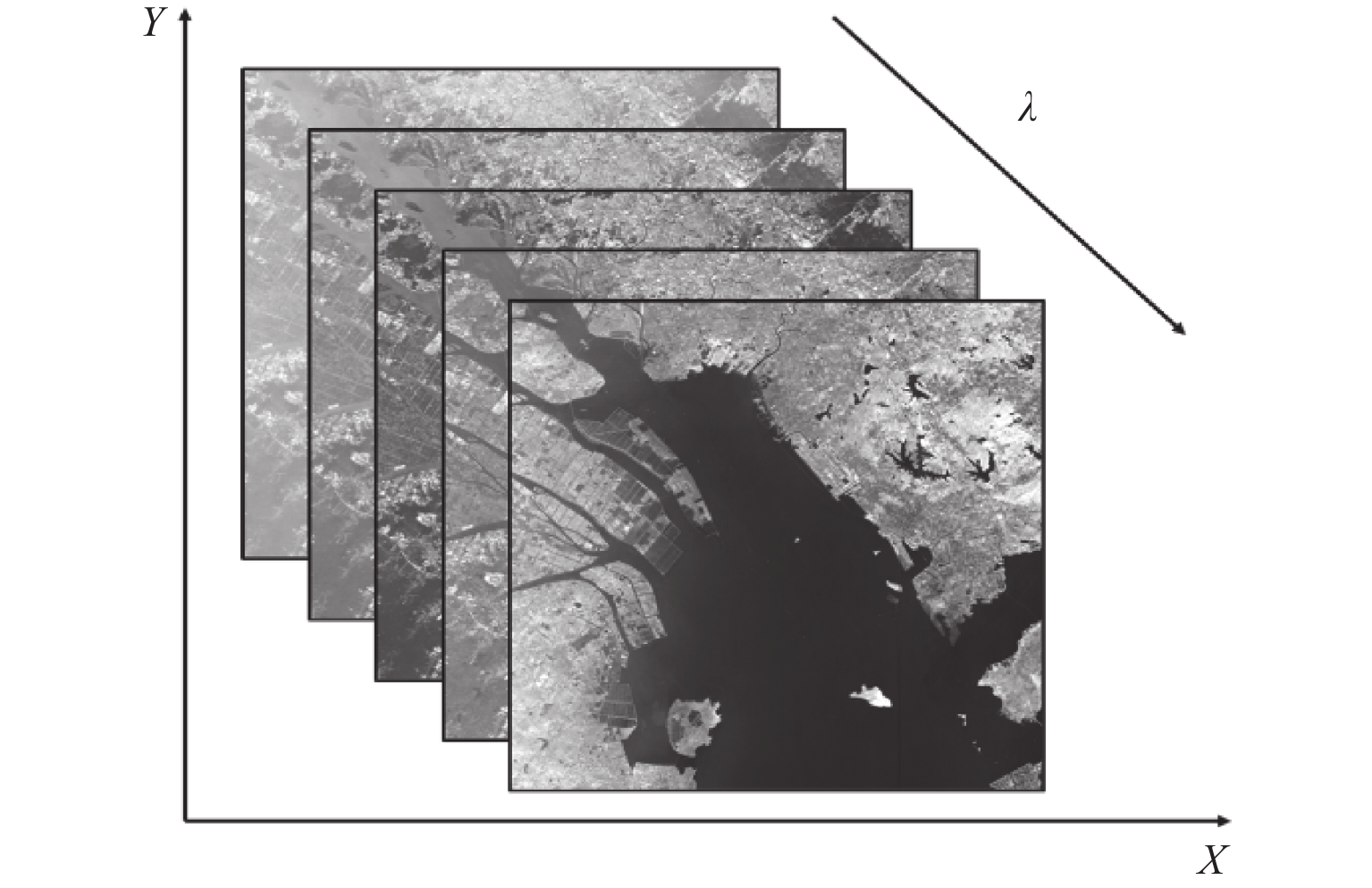
综上所示,包含32个光谱通道的OHS-C高光谱卫星所采集的高光谱图像能够满足森林和水体鉴别以及测绘的要求。由32个通道的单波长图像可以构成包含二维空间信息以及一维光谱信息的高光谱立方体,进而实现对图片中任一像素点的光谱的提取,如图1所示,X和Y轴表示二维空间信息,Z轴表示图片的波长信息,构成一个既包含空间信息又包含光谱信息的光谱立方体。
1.3 光谱数据提取及分析
如上文分析,本研究将地物分为3类:第1类是水体,主要包括海水、河流、水库、湖泊、沿海水田等;第2类为林木,主要包括森林公园、城市绿植和绿色农作物等;第3类为建筑物,主要包括房屋、道路及桥梁等。为了对3类目标物的光谱特征进行准确分析并为自适应鉴别模型提供足够丰富的训练样本,本研究利用图中较易辨认的水体、林木和城市对应的像素点进行特征光谱的提取。同时,在选择坐标点时,充分考虑其多样性。如水体坐标选取时,会分别选择湖泊、水库、河流、海洋等位置的像素点。图2展示了水体、林木和建筑物部分光谱取样点的位置,其中,图片中心波长为896 nm,水体取样点为蓝色方点,林木取样点为绿色圆点,建筑物取样点为橙色三角点。
图3展示了分别采集水体、林木和建筑物的200组光谱计算得到的3种地物的平均反射光谱线曲线。可以看到林木的特征光谱曲线在600 nm附近出现波谷,并出现了反射红边和长波的反射平台,与叶绿素的反射光谱能够很好地对应;水体的特征光谱曲线在730 nm附近出现一段下降趋势,符合水体光吸收特点;建筑物各个波段发射率较高,光谱区域平坦,也符合建筑物的反射光谱情况。3种地物的光谱存在明显差异,因此可实现分类鉴别。
2 模型训练和鉴别
2.1 模型训练
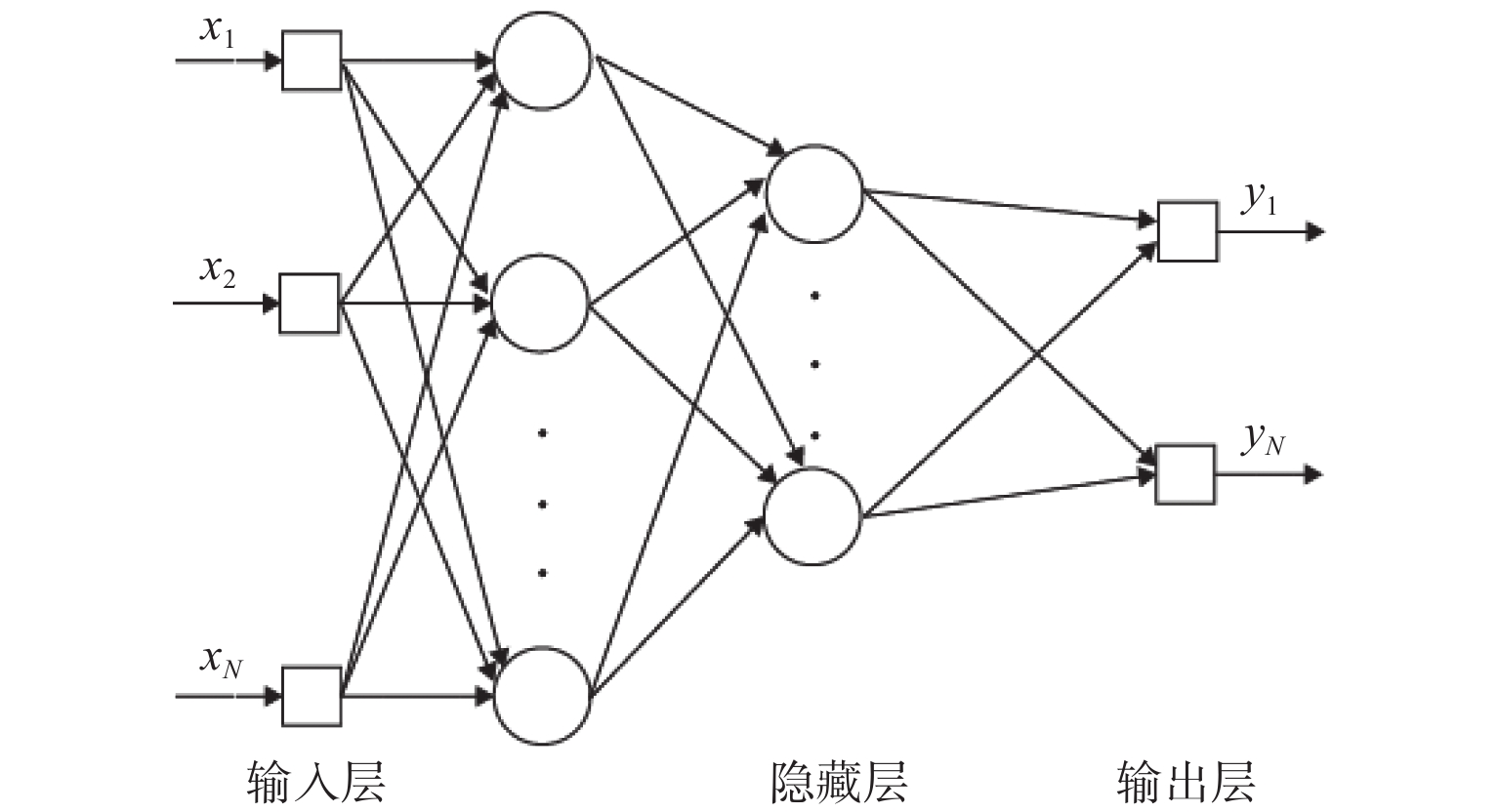
本研究采用BP神经网络自适应算法对水体、林木和建筑物等3类地物的光谱进行训练学习,形成判别模型,用于实现图中各种地物的鉴别和标定。BP神经网络类似于一个只有输入输出且看不到中间的运行计算环节的黑箱。虽然中间过程无法看到,但其隐含层根据数据有着一定学习规则可以存储利用,所以可以训练这种网络使之具备有一定的预测能力。BP神经网络由多层构成,层与层之间全连接,同一层之间的神经元无连接。它的工作信号沿着网络结构进行正向传播,而误差信号则沿着网络结构反向传播。其网络结构如图4所示。
本研究共采集了1430组光谱数据,其中训练组600组数据(水体、林木和房屋各200组),测试组830组数据(水体400组,林木430组)。大气变化和日照变化均会影响反射光谱,为了使鉴别方法适合于任何情况,并考虑到本研究旨在通过光谱对3类地物进行鉴别,在光谱处理方法上,在不改变目标的基础上对其进行了演化。由于大气、时刻、季节等变化最终影响的是阳光在入射和发射过程中的光强,假设太阳光到达地面时其波长为λ的部分的强度为Ii(λ),大气对此波长光波的吸收、散射等总损耗系数为α(λ),而目标物体1其中同一位置对波长为λ的光波的反射率为R1,则被卫星采集的该波长的光强I1(λ)为
$$ {I}_{1}\left(\lambda \right)=\alpha \left(\lambda \right){R}_{1}\left(\lambda \right) \cdot {I}_{i}\left(\lambda \right) $$ (1) 同理,可以求得:
$$ {I}_{2}\left(\lambda \right)=\alpha \left(\lambda \right){R}_{2}\left(\lambda \right) \cdot {I}_{i}\left(\lambda \right) $$ (2) $$ {I}_{3}\left(\lambda \right)=\alpha \left(\lambda \right){R}_{3}\left(\lambda \right) \cdot {I}_{i}\left(\lambda \right) $$ (3) 若以3类地物的光强分别除以第1类地物某点处的光强I1(λ),则可以得到:
$$ \frac{{I'}_{1}\left(\lambda \right)}{{I}_{1}\left(\lambda \right)}=\frac{{R'}_{1}\left(\lambda \right)}{{R}_{1}\left(\lambda \right)} $$ (4) $$ \frac{{I}_{2}\left(\lambda \right)}{{I}_{1}\left(\lambda \right)}=\frac{{R}_{2}\left(\lambda \right)}{{R}_{1}\left(\lambda \right)} $$ (5) $$ \frac{{I}_{3}\left(\lambda \right)}{{I}_{1}\left(\lambda \right)}=\frac{{R}_{3}\left(\lambda \right)}{{R}_{1}\left(\lambda \right)} $$ (6) 由(4)~(6)式可知,处理后所获得的比值仅与它们的反射率有关,与太阳光情况无关,可克服大气、光照等变化带来的影响。在本研究中,由于水体具有易于识别、各处光谱较为均匀和稳定的特点,利用水体一固定点处的光谱作为基准(I1)逐一与采集到的目标物的光谱进行相除。
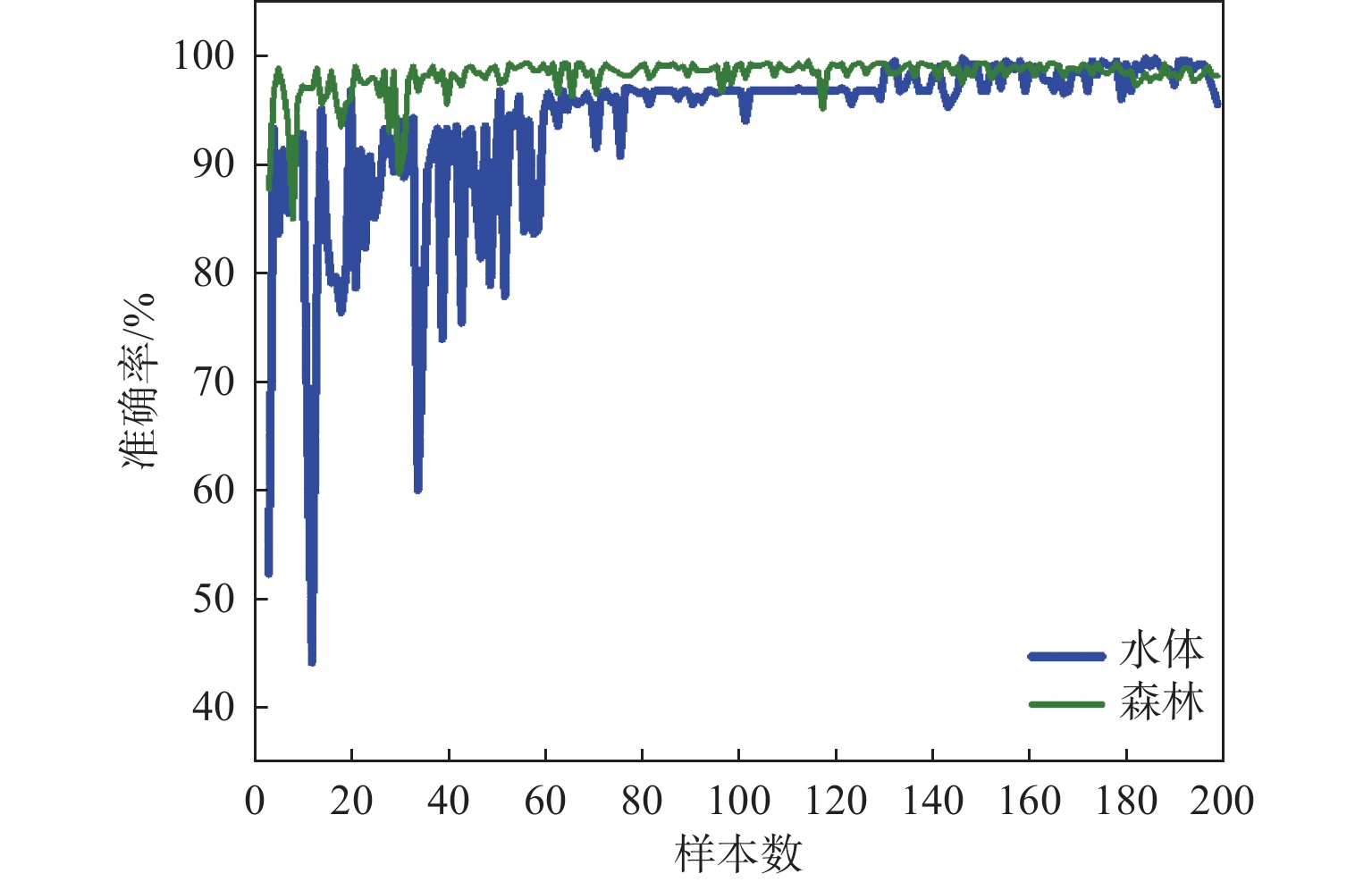
所有采集的光谱数据均按上述方法进行处理,其中训练组数据送入BP神经网络。本研究所采用的神经网络的隐含层神经元个数为19,其学习率为0.01,迭代次数为1500,均方根误差为1%。神经网络是一种自适应算法,它的判别准确率和训练样本量有着密切的联系。为了验证训练组的光谱数据是否足够,我们采用包含不同样本量的训练组对模型进行训练,并用同一个测试组进行测试。由图5可知,当训练组的样本量大于50的时候,准确率趋于稳定,因此可以确定由600组光谱数据组成的训练组其训练样本已经足够。
2.2 鉴别
采用经过训练后的BP神经网络模型,对测试组的400组水体光谱数据和430组林木光谱数据进行鉴别,结果如表4所示。
表 4 灵敏度与特异性统计结果Table 4. Statistical results of sensitivity and specificity统计结果 水体 林木 灵敏度 水体 389 11 97.25% 林木 7 423 98.37% 特异性 98.23% 97.47% — 检测结果表明,水体和林木的灵敏度和特异性均在97%以上(具体指出水体和林木的灵敏度和特异性)。
3 林木/水体面积测绘
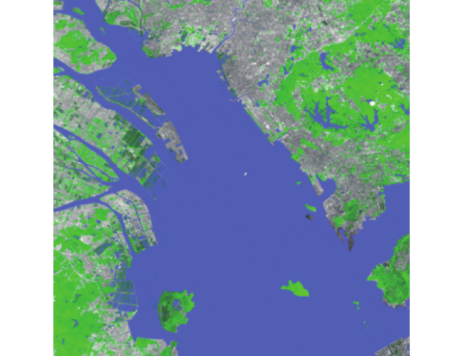
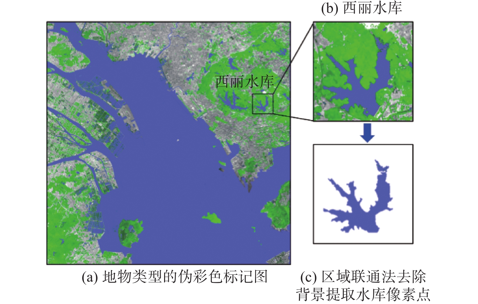
通过上述BP神经网络模型对图片中每一个像素点进行地物类型的鉴别,并利用不同的伪彩色进行标记,其中水体标记为蓝色,林木标记为绿色,建筑物保持原灰度标记,如图6所示。
从伪彩图中可清晰地看到水体和林木的分布情况。根据全图鉴别结果,分别统计了图中被鉴别为水体和林木的像素点个数,再根据像素点与实际面积的比例关系,对水体和林木面积进行了统计,具体如表5所示。
表 5 水体及林木面积监测Table 5. Area monitoring of water and forest地物种类 像素点个数 对应面积/km2 水体 12432 650 1243.2650 林木 5113125 511.3125 其他 8017361 801.7361 全图 25563136 2556.3136 为了验证测绘计算的准确性,我们在鉴别结果的基础上,通过区域联通算法单独提取了西丽水库和淇澳岛对应的像素点(图7和图8),并统计了像素点的个数和其对应真实面积(见表6)。
表 6 测绘面积验证Table 6. Verification of surveying and mapping area地物 总像素
点个数测绘面
积/km2实际面
积/km2面积误
差/km2西丽
水库44554 4.4554 4.6 0.1446 淇澳岛 221713 22.1713 23.8(官方统
计绿化程
度90%以上)<0.7513 由表6可知,通过本文所述方法可计算出西丽水库的水域面积为4.4554 km2,官方公布的该水库水域面积数据为4.6 km2,误差为0.1446 km2,误差率为3.14%。淇澳岛的绿化面积为22.1713,该岛总占地面积为23.8 km2,绿化区域占地面积为90%以上,按照90%绿化计算得误差小于0.7513 km2。考虑到商用高光谱卫星空间分辨率的限制(空间分辨率为10 m),此测绘结果已经非常精准。
4 结论
本文基于“珠海1号”高光谱卫星(OHS-C)所提供的高光谱卫星图片,利用目标物光谱的相互关系在鉴别前对光谱进行了预处理,结合BP神经网络自适应算法,实现了对森林和水体的鉴别、增强标记和面积测量。研究结果表明,尽管受商用高光谱卫星空间分辨率的限制,本文所述的测绘方法依然能实现较为精确的面积测绘,卫星图中的森林和水体均能被准确鉴别和标记,判别灵敏度和特异性均高于97%。本文方法具有简单快捷、鉴别准确率高且测绘面积精准的特点,能够有效对不同地物环境等进行鉴别研究,具有良好的发展潜力和应用前景。
-
表 1 “OHS-C”高光谱卫星拍摄数据简介
Table 1 Brief introduction of “OHS-C” hyper-spectral satellite shooting data
内容 简介 星号 OHS-C 左上角点经纬 Lon. E113°36′48′′ Lat. N22°45′11′′ 成像时间 2018年9月15日 侧摆角 −10.326° 太阳高度角 62.073° 影像分辨率 5056× 5056 像素 轨道高度 520 km 地物描述 城市、森林、湖泊、海洋 地面分辨率 10 m 数据处理等级 1级 已完成预处理项 相对辐射定标、几何校正 表 2 “OHS-C”高光谱卫星中心波长表
Table 2 Central wavelengths of “OHS-C” hyper-spectral satellite
通道数 中心波长/nm 通道数 中心波长/nm 1 466 17 716 2 480 18 730 3 500 19 746 4 520 20 760 5 536 21 776 6 550 22 790 7 566 23 806 8 580 24 820 9 596 25 836 10 610 26 850 11 626 27 866 12 640 28 880 13 656 29 896 14 670 30 910 15 686 31 926 16 700 32 940 表 4 灵敏度与特异性统计结果
Table 4 Statistical results of sensitivity and specificity
统计结果 水体 林木 灵敏度 水体 389 11 97.25% 林木 7 423 98.37% 特异性 98.23% 97.47% — 表 5 水体及林木面积监测
Table 5 Area monitoring of water and forest
地物种类 像素点个数 对应面积/km2 水体 12432 650 1243.2650 林木 5113125 511.3125 其他 8017361 801.7361 全图 25563136 2556.3136 表 6 测绘面积验证
Table 6 Verification of surveying and mapping area
地物 总像素
点个数测绘面
积/km2实际面
积/km2面积误
差/km2西丽
水库44554 4.4554 4.6 0.1446 淇澳岛 221713 22.1713 23.8(官方统
计绿化程
度90%以上)<0.7513 -
[1] MACDICKEN K G. Global forest resources assessment 2015: what, why and how?[J]. Forest Ecology and Management,2015,352:3-8. doi: 10.1016/j.foreco.2015.02.006
[2] 严承高, 陈建伟. 从生物多样性保护浅谈我国森林经营与管理对策[J]. 中南林业调查规划,1995,14(1):37-41. YAN Chenggao, CHEN Jianwei. A brief discussion on forest management and management strategies in my country from the perspective of biodiversity protection[J]. Central South Forestry Survey and Planning,1995,14(1):37-41.
[3] 生态环境部, 农业农村部, 水利部. 关于印发《重点流域水生生物多样性保护方案》的通知[J]. 中华人民共和国国务院公报,2018(28):71-79. Ministry of Ecology and Environment, Ministry of Agriculture and Rural Affairs, Ministry of Water Resources. Circular on printing and distributing the "plan for the protection of aquatic biodiversity in key river basins"[J]. Bulletin of the State Council of the People's Republic of China,2018(28):71-79.
[4] JONATHAN S, YIJING X, ELI N, et al. Intraoperative multispectral and hyperspectral label‐free imaging: a systematic review of in vivo clinical studies[J]. Journal of Biophotonics,2019,12(9):e201800455.
[5] 张东东, 周振, 宋晓东. 基于HJ卫星的中国南方地区甘蔗面积提取研究[J]. 中国农学通报,2019,35(16):141-147. doi: 10.11924/j.issn.1000-6850.casb18030081 ZHANG Dongdong, ZHOU Zhen, SONG Xiaodong. Extraction of sugarcane area in southern China based on HJ satellite[J]. China Agricultural Science Bulletin,2019,35(16):141-147. doi: 10.11924/j.issn.1000-6850.casb18030081
[6] 何坦, 唐庆霞, 郑亚慧. 基于卫星遥感技术的鄱阳湖水体面积快速监测[J]. 价值工程,2013,32(19):213-215. doi: 10.3969/j.issn.1006-4311.2013.19.115 HE Tan, TANG Qingxia, ZHENG Yahui. Rapid monitoring of poyang lake water area based on satellite remote sensing technology[J]. Value Engineering,2013,32(19):213-215. doi: 10.3969/j.issn.1006-4311.2013.19.115
[7] ASFAW W, HAILE A T, RIENTJES T. Combining multisource satellite data to estimate storage variation of a lake in the Rift Valley Basin, Ethiopia[J]. International Journal of Applied Earth Observation and Geoinformation,2020,89:102095. doi: 10.1016/j.jag.2020.102095
[8] GREGORY P A, PHILIP G B, CHRISTOPHER P, et al. Mapped aboveground carbon stocks to advance forest conservation and recovery in Malaysian Borneo[J]. Biological Conservation,2018,217:289-310. doi: 10.1016/j.biocon.2017.10.020
[9] LAURA C, CRAIG M, KOREEN M, et al. Remote sensing of boreal wetlands 2: methods for evaluating boreal wetland ecosystem state and drivers of change[J]. Remote Sensing,2020,12(8):1321. doi: 10.3390/rs12081321
[10] YAGMUR N, TANIK A, TUZCU A, et al. Oppurtunities provided by remote sensing data for watershed management: example of konya closed basin[J]. International Journal of Engineering and Geosciences, 5(3): 120-129.
[11] GBAGIR A M G, TEGEGNE Y T, COLPAERT A. Historical trajectory in vegetation cover in Northeastern Namibia based on AVHRR satellite imagery (1982–2015)[J]. Land,2019,8(11):160. doi: 10.3390/land8110160
[12] 彭继达, 张春桂, 李丽纯. 基于Landsat影像的平潭综合实验区设区前后植被变化特征分析[J]. 陕西气象,2020(3):49-53. doi: 10.3969/j.issn.1006-4354.2020.03.010 PENG Jida, ZHANG Chungui, LI Lichun. Analysis of vegetation change characteristics of pingtan comprehensive experimental area before and after the division based on landsat image[J]. Shaanxi Meteorology,2020(3):49-53. doi: 10.3969/j.issn.1006-4354.2020.03.010
[13] 彭继达, 张春桂. 基于高分一号遥感影像的植被覆盖遥感监测—以厦门市为例[J]. 国土资源遥感,2019,31(4):137-142. PENG Jida, ZHANG Chungui. remote sensing monitoring of vegetation coverage based on gaofen-1 remote sensing image: taking xiamen city as an example[J]. Remote Sensing of Land and Resources,2019,31(4):137-142.
[14] DU L, MCCARTY G W, ZHANG X, et al. Mapping forested wetland inundation in the delmarva peninsula, USA using deep convolutional neural networks[J]. Remote Sensing,2020,12(4):644. doi: 10.3390/rs12040644
[15] 傅肃性. 遥感专题分析与地学图谱[M]. 北京: 科学出版社, 2018. FU Suxing. Thematic analysis of remote sensing and geoscience atlas[M]. Beijing: Science Press, 2018.


 下载:
下载:



 陕公网安备 61011302001501号